Lords
of the Earth, Campaign 51: Maps
Last
edited: September 16, 2026
Intro
The
populations are scattered about learning to deal with advancement in
its own ways and with magic to assist them. Once populations
increased putting stress on the more centralized regions, there was
more nomadic movement of people between areas and resources. Some
hive minded creatures have formed degrees of communication with
humans. For now this has caused some trade possibilities and other
resources to become available or to be traded. This is where the
start of the campaign comes on. Some of these ideas related to
population have come from Lords 38 which did a fine job of exploring
the Bronze Age.
Technical
side note
There
is a base Black and White map and a full Color map. Those maps are
made up of 6 normal 8 ½ x 11 pieces of paper in landscape
mode. 3 on top, 3 on the bottom.
Technically this campaign
uses Campaign Cartographer 3+ (CC3+) for the creation of the base
map. I do plan on using exports from both CC3+ and the xStats GM
Software for Lords of the Earth to allow some automation to take
place. As of the summer of 2026 I've been able to make progress with
this, but it is not yet fully functional. In addition, the QGIS
tools used to export a functional searchable page take some work and
from what I have seen do not allow for customization in their easy to
use form. Once we get into programming, anything can be accomplished
but the value of that time spent cannot be justified frankly.
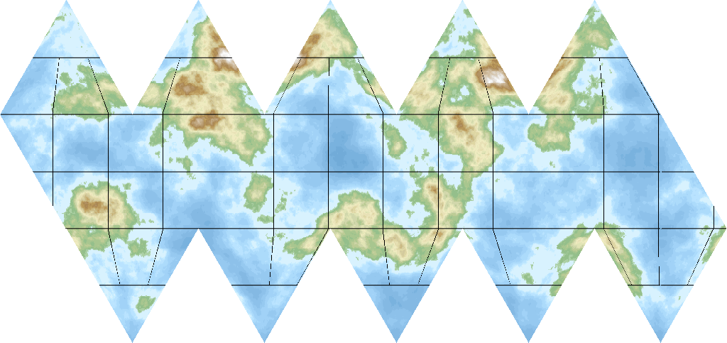
Fractal terrain generated planet
4.0
The Map
The
natives call this planet Alrai. At the beginning of the campaign
only the most central larger land mass will be used for the players.
Consider populations of smaller bands were moving about or wiped out
entirely by flood, land slide, volcanic activity and so on. Other
places people thrived and put down more sustainable roots. This is
reflected in the population of regions. I've also included notes in
the region information on the stat sheets too. Two examples: - / -
would be “uninhabited”, while ½ – 4 would
note “half populated” with a Resistance Value of 4. The
normal rules discuss - / -, 0 population regions as well as
depopulated regions so this is not as out of the box as it may first
appear.
4.0.1
Half-Populated Regions (L38)
The
Resistance Value (RV) is treated in two ways:
- for
combat-related purposes such
as size of native army and size of garrison, use ½ the RV
rounded up.
- for
diplomacy
or actions related the beliefs and attitude of the people, the full
RV is used.
Once Pacified, or raised by diplomacy to F status
it could be:
- colonized
for 12.5 gp and 7 nfp as per 5.4.14.5 (or very close depending on
rule version) Colonizing Populated Regions, using ½ for the
Gpv when calculating cost.
-
settled
by a migrating nation per 10.8.3.1 Settling in Populated Areas by the
use of ½ a Tribal Point.
In
either case the region would now be (or remain) friendly status and
have the player control and map symbols. The player nation's society
would become Caste if the half-populated region's previous status had
been Pacified.
4.1
Regional Symbols
Terrain
symbols are not the same. They are just letters, shown under or very
near the name of the region. GPvalue, RV, a slash and a letter
signifying they type of region. C2 (not in the game at the start),
(C)ultivated, (I)sland, (J)ungle, (JS)ungle swampy, (Jc)ungle with
half cultivation, (S)teppe, (Sc)teppe with half cultivation,
(W)ilderness, (Wc)ilderness with half cultivation, (M)ountainous,
(Ms)ountain steppe like, and (D)esert.
Elemental symbols
|

Wood
|

Fire
|
Earth
|

Metal
|
Water
|
Trade
Center symbols are all circular with an image or something in the
middle. In the color version of the map this is red. There are also
trade centers in some Sea Zones, that will be further detailed in
Section 4.6 below
A detailed Legend will also be on the map.
4.1.1.1
Settlements (L38 inspired)
A
city rectangle with a S inside is a Settlement with enough
inhabitants to be halfway towards becoming a city. Settlements can
be found anywhere upon the map.
Settlements which have a port
anchor symbol and is:
- at least NT status, it is considered a
port for movement and tracing CCR. (a
bit tenuous, but possible)
-
at least T status, it may serve as one end of a trade route. Since
it is basically a 0 GP city no MSP may be assigned there. It may not
be used as a “conduit” city until it is 1 GPv
4.1.2
Fortresses
The
same symbol will be used to display a Fortress of a given area and a
city with a fortress.
4.3.2
Trade Routes (often The Silk Route)
A
2 pixel width dark brown line will be used for trade routes that
duplicate the effect of “The Silk Route”. At the start
of the campaign is a route between suppliers of food stuffs and the
Ants of G'TKK. This route runs for the most part along a lower
elevation in a north – south direction. This is not the only
route possible, it is the one which is active at the start.
4.3.3
Giant Bugs, Bees replaces The Arctic Fur Trade
Regions
adjacent to such areas have an (F) listed in their description. Any
controlled region will also have the F designation on the stat sheet
indicating the equivalent benefit as if it were next to the Fur Trade
Zone.
4.4
Border Terrain
The
same types listed in table 4.3 exist. Small Mountains – type
1, Large Mountains – type 2, Navigatable Rivers, and Megolithic
Constructs including Great Wall sections.
A key change to
movement in Lords 51. Elevation. Most if not all of the lower
elevation is taken by vast forests which grow into wilderness as the
elevation changes. This is designated by an entire polygon much like
a massive contour line. Slightly off color grey in the Black / White
map and multi hew brown in the colored map. When effects are turned
on it is obvious in a type of 3d effect to the color map border.
This is not so much a cliff of 1000 feet or something, but the
indication that a change is taking place geographically that is also
causing the land cover to adjust to new environmental conditions.
Rivers on the map which enter these elevated lands sometimes offer
passage by watercraft, other times the change does not allow boats of
any type. This is indicated with that wording. “boats”
with a slash going through the middle. Either way, it is considered
a water source for the purposes of public works and city size noted
on those related tables of 5-5 Max Public Works Bonus and 5-8 Max
City Size by Terrain.
4.5
Terrain
The
Jungle designated as JS is Jungle Swamp. This indicates not only
thick heavy undergrowth, but low always wet terrain. Think of
portions of the Amazon near the river. This type of terrain is
treated like Jungle for all economic purposes. The JS regions are
also permanent without possibility of full cultivation. Depending on
xStats (the GM software) it will either say terrain type J then list
“swamp” in the notes or actually have JS as the
type.
Jungle of any kind grows quite rapidly, any cleaning not
maintained will return to Jungle within a few years time. If a
region is depopulated, whatever the reason it will begin to
revert.
Half-cultivated
terrain (inspired
by L38):
regions
that can
be cultivated include Jungle, Steppe, and Wilderness indicated on the
map with a “c” next to the terrain letter. Mountain
regions can be extensively explored and the best places found for
small herds, grow a limited amount of food, and so forth. In
general, these regions represent considerable “forest
agriculture” where farming, herding, & gathering are taking
place, but not a complete regional transformation.
A
megolithic construction of a half-cultivation
project
will also produce these regions. It is a base ½ level costing
25 gp & 13 nfp with the usual modifications by culture type. A
benefit list includes higher ITV, more regional income, agro benefits
for troops and cities, and expanded public works options to name a
few.
4.5.1
Intensely Cultivated (C2 Regions)
There
are no C2 regions or the ability to convert a region has not yet been
completed.
4.6
Sea Symbols
An
addition to the campaign, certain Sea Zones have increased potential
capacity. Some of them even hold Aether Pearls which have limited
capacity to expand the storage capacity of magic in a nation.
Further details will be explained in the economic portion of the
rules.
4.6.5
Lighthouses
Some
normally (H)ostile Sea Zones have a number by them. Lake Umilwen for
example has H
(3)
This
indicates if three regions bordering the Lake have Lighthouses in
them, it will no longer be Hostile to anyone traveling there due to
dangerous shores and such. Lighthouses will be listed in the Table
13-4 Unit Construction which also shows on the bottom of your Stat
Sheet. It is the same cost as 2 Field Forts and acts as such. Each
region can hold one Lighthouse, so it takes either a larger nation to
construct all of them or a combined effort from neighboring
nations.
4.7
Ferry Arrows
Trade
across a ferry site is LTH (Land Trade across Hostile terrain) until
10 ferry points are built, at which point it improves to LTD (Land
Trade across Difficult terrain) Ferry Point locations can
potentially exist across rivers or narrow bits of the open sea.
Rivers
The
exploration of any given river now has a set Resistance Value (RV) to
get the Explored status on a stat sheet. Once explored often Light
ships can travel them, potentially others. If there is a river
system or multiple parts to a single river zone, then travel across
those sections is indicated on the map. It might be the case that
while moving through regions you cross a portion of a river, then
another portion later in a single turn.
Rivers listed
alphabetically:
Drak'tu River – one zone from the Beag Loch
Khurnak River – one zone from the Beag Loch serving as the
border between Rivohn and Lidena
Thur'q River System –
considered one zone, can travel the Thur'q Tributary. Movement
penalty by portion
Ghrak River – one zone
Khra'd River –
one zone from Lake Seirashi
Brag'Tu River Zone – all one
zone with branches and lakes individually indicated by direction and
name.
Durana River – the mouth of a multi river system,
leads to Bravus River which heads north
Bravus River –
connecting to the Durana River, a tributary the Granum River runs
into it
Serune River – one zone with an East branch, allows
Light or Medium vessels towards the mouth
Claurs River – a
small river zone connected to the Nerikai Notch sea zone
Vulnor
River – a single zone forked river with a North branch
connected to the Sorakai Gulf sea zone
Slavos River – a
small river zone in the far northeastern portion of the map
Runara
River - a small river zone in the far northeastern portion of the
map
Kaldus River – a small river on a larger island landmass
to the East
Ferris Waterway – a river & set of small
lakes joined as a single zone on larger island landmass to the
East
Faylen River – a small river zone connected to the
Suilora Coast sea zone
Ostria River – a small river zone
between Hook Lake and the Suilora Coast sea zone
Ta'Lion Gorge
River – a small inland river zone connected to Lake
Namilin
Nerune River – a single river zone, deep at first
until it climbs higher connected to some inner sea zones